GIS data acquisition
Geographic Information Systems
A Geographic Information System (GIS) is an integrated set of hardware and software tools, designed to capture, store, manipulate, analyse, manage, and digitally present spatial (or geographic) data and related attribute information. GIS can relate information from different sources, using two key index variables space (or location) and time. Common GIS data types (models) include:
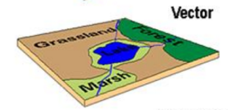
Spatial Data: Describe the absolute and relative location of geographic features.
Vectors
Arcs (Polylines): Line segments forming individual linear features
Polygons: Areas enclosed by arcs
Points: Single coordinate pairs
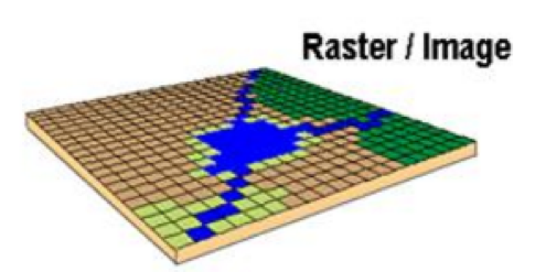
Rasters
Grid-Cells: single column/row positions
Cell size: Resolution or else the accuracy of the data
Attribute data: Describe characteristics of the spatial features. These characteristics can be quantitative and/or qualitative in nature. Attribute data is often referred to as tabular data.
The selection of a particular data model, vector or raster, is dependent on the source and type of data, as well as the intended use of the data. Certain analytical procedures require raster data while others are better suited to vector data.
GIS data in OnSSET
OnSSET is a GIS-based tool and therefore requires data in a geographical format. In the context of the power sector, necessary data includes those on current and planned infrastructure (electric grid networks, road networks, power plants, industry, public facilities), population characteristics (distribution, location), economic and industrial activity, and local renewable energy flows. The table below lists all layers required for an OnSSET analysis.
# |
Dataset |
Data type |
|---|---|---|
1 |
Administrative boundaries |
Polygon |
2 |
Existing Medium-voltage lines |
Lines |
3 |
Planned Medium-voltage lines (Optional) |
Lines |
4 |
Distribution transformers (MV/LV) |
Points |
5 |
Substations* |
Points |
6 |
Existing High-voltage lines |
Lines |
7 |
Planned High-voltage lines (Optional) |
Lines |
8 |
Road network |
Lines |
9 |
Settlement clusters |
Polygons |
10 |
Global Horizontal Irradiation (GHI) |
Raster |
11 |
Small scale hydropower sites |
Points |
12 |
Wind velocity (m/s) |
Raster |
13 |
Travel time (min) |
Raster |
14 |
Night-time lights |
Raster |
15 |
Existing mini-grid locations |
Points |
16 |
Custom demand layer (if bottom-up approach is included) |
Raster |
17 |
Location of Health Facilities (if social uses are included) |
Points |
18 |
Location of Education Institutions (if social uses are included) |
Points |
Note
Before a model can be built, one must acquire the layers of data outlined above.
You are recommended to use most of the layers listed in the table above, but some of the are optional and can be omitted (see table above)
More often than not, each layer must be acquired on its own. The final outcome is a .csv-file conveying all the information necessary to initiate an OnSSET electrification analysis.
Specific GIS datasets
The following sections outline some starting points for GIS data collection. Generally, country-specific data sources such as the national statistics office, Ministry of Energy, power utility, etc. have the most up-to-date datasets, which should be prioritized. Here we list some openly accessible databases.
Population/settlement clusters
These settlement polygons form the basis of the OnSSET analysis. A readily available dataset is available here for sub-Saharan African countries based on the methodology described in this publication. Note that these are several years old, and updated ones can be created using this code.
Administrative boundaries
Administrative boundaries are freely available for academic use and other non-commercial use from the Database of Global Administrative Areas (GADM), but best retrieved from national statistics office or similar.
Travel time
Travel time indicates the time it takes to travel by car from any point in the country to the largest city with >50,000 people. This dataset is typically retrieved from the Malaria Atlas Project (check under Accessibility > *Global Travel Time to Cities). Note that the data is from 2015, and newer datasets should ideally be used.
Global Horizontal Irradiation (GHI)
GHI indicates the annual solar resource potential in each location in a country. This can be retrieved from the Global Solar Atlas. Look for a file called Gis data - LTAym_YearlyMonthlyTotals (GeoTIFF).
Note that in some countries only the daily solar resource is available. In this case, look for a file called GHI - LTAym_DailySum (GeoTIFF), which then needs to be multiplied by 365 using the Raster calculator in QGIS or similar before use.
Wind Velocity
The average annual wind speed (m/s) can be retrieved from the Global Wind Atlas. Make sure to select the country, for layer select WIND-SPEED, and for height select 50.
Hydro-power potential
The hydro-power potential dataset indicates locations where small and mini-hydropower can be installed for mini-grids (i.e. not large-scale hydropower for supplying the national grid). A version for sub-Saharan Africa is available here based on the methodology described in this publication. Note that the dataset is quite old and new updates should be undertaken if no country-specific dataset is available.
GIS databases
The following lists some important GIS databases where much data can be retreieved
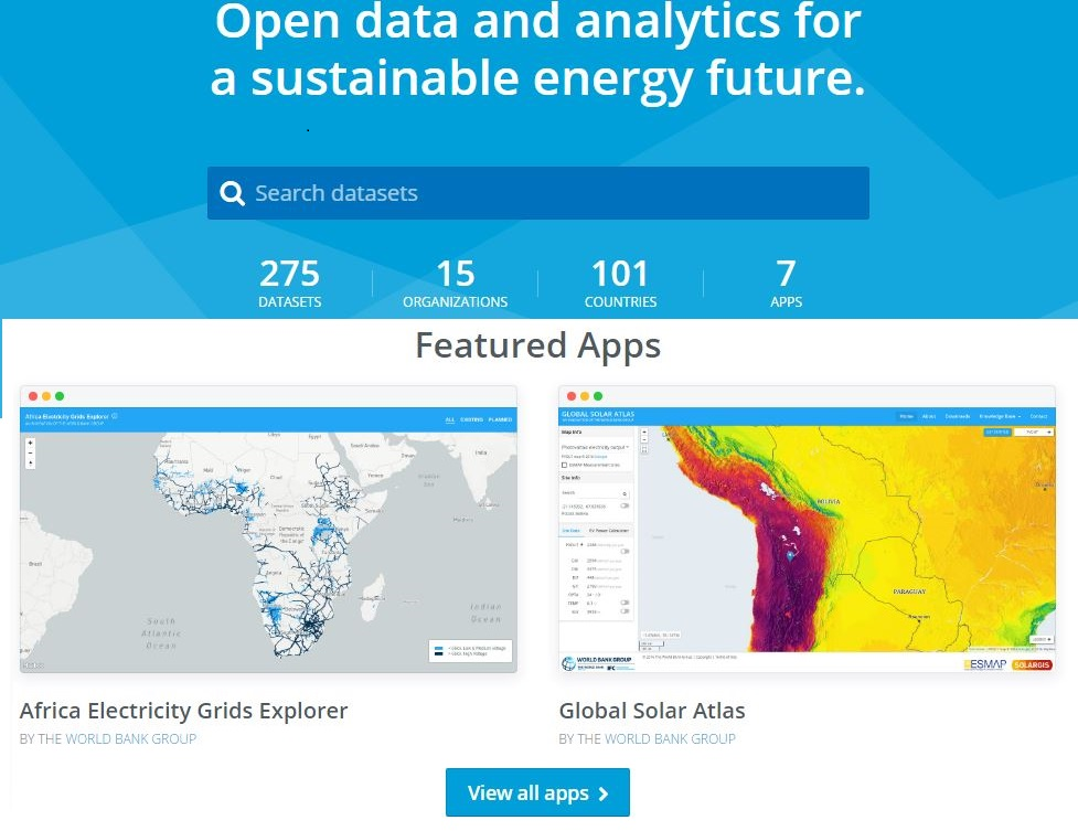
EnergyData.info
Every day governments, private sector and development aid organizations collect data to inform, prepare and implement policies and investments. Yet, while elaborate reports are made public, the data underpinning the analysis remain locked in a computer out of reach. Because of this, the tremendous value they could bring to public and private actors in data-poor environments is too often lost.
Energydata.info is an open data platform by The World Bank Group and several partners, trying to change energy data paucity. It has been developed as a public good available to governments, development organizations, non-governmental organizations, academia, civil society and individuals to share data and analytics that can help achieving universal access to modern energy services. The database considers a variety of open, geospatial datasets of various context and granularity, including many datasets on existing power infrastructure.
Humanitarian Data Exchange
The Humanitarian Data Exchange (HDX) is an open platform for sharing data across crises and organisations. It contains much useful data, including GIS data. In particular, it contains administrative boundaries, health and education locations, and links to other similar projects.
Geofabrik / OpenStreetMap
The Geofabrik server has data extracts from the OpenStreetMap project which are normally updated every day. You can find data for any country here. In particular, it includes road data. OpenStreetMap also provide data such as substations. in case not available anywhere else.
Country specific databases
With geospatial analysis gaining momentum in many research areas, many countries have set up their own geo-databases in an effort to facilitate interdisciplinary research activities under a geospatial context. Here are few examples of country-specific databases useful for electricity planning:
Database |
Countries |
|---|---|
India, Nigeria, Zambia, Kenya, Nepal, Tanzania, Ethiopia, Uganda |
|
Madagascar |
|
Uganda |